


Satellite gravimetry missions like GRACE and GRACE Follow-On (GRACE-FO) have mapped the Earth’s time-variable gravity field for over two decades. Both missions consist of two near-polar satellites in an inline formation, with an inter-satellite link (ISL) for ranging. This mainly along-track ISL geometry is understood to cause the characteristic north-south striping artefact in GRACE(-FO) data. In contrast, emerging mega-constellations have hundreds to thousands of satellites spread across various orbital planes, inclinations, and altitude bands. This can provide much more diverse ISL directions than a conventional along-track formation. This motivates us to investigate whether a more diverse set of ISL directions could yield more isotropic error behaviour of the recovered gravity field and to explore the potential of mega-constellations for gravity field mapping as a satellites-of-opportunity concept.
Additionally, the VLEO regime unlocks increased sensitivity to Earth's gravity field along with new challenges of operating satellites in VLEO.

Caption: The figure shows the rise in satellite launches since 2020, along with a snapshot of a couple of mega-constellation operators and their satellites. / M.Abhishek
Simulation Approach
The study involves conducting several simulations for various mission scenarios to evaluate their gravity recovery potential. We adopt a reduced-scale closed-loop simulation approach to test all possible design and recovery parameters. We implement the approach as a Julia package. The package is currently a work in progress and is being continually updated.
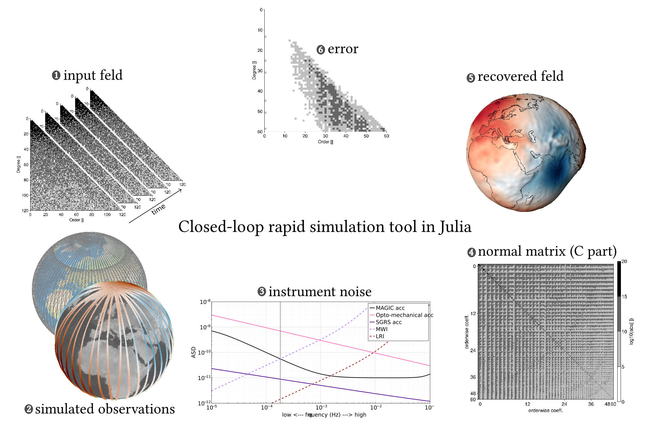
Caption: The rapid simulation setup starts with a specific mission configuration in mind, which can be studied for its gravity-recovery potential. The input field can be simulated using static field models, the ESA Earth System Model (ESM), and tidal models expressed as spherical harmonic coefficients. Using these models, we synthesise ideal observables along the satellite's orbit. Appropriate instrument noise can be added to make them realistic. We then use these "realistic observations" in a least-squares estimation process to recover the spherical harmonic coefficients up to a specified maximum degree. We can then analyse the recovered coefficients in the spatial and spectral domains. / M.Abhishek
Funding
This work is funded by the Deutsche Forschungsgemeinschaft (DFG, German Research Foundation) – Project-ID 516238647 – SFB 1667/1 (ATLAS - Advancing Technologies of Very Low-Altitude Satellites)
Nico Sneeuw
Prof. Dr.-Ing.Head of Institute, Chair of Physical and Satellite Geodesy, Dean

Abhishek Mhamane
M.Sc.Scientific Employee