
Professor Foster is leading a collaborative project with the University of Hawaii and the Scripps Institute of Oceanography to deploy a seafloor geodetic network on the submarine flank of Kilauea Volcano, Hawaii. The $2M effort, funded the US National Science Foundation, will deploy 4 GNSS-A sites to measure horizontal displacement rates along a profile over Kīlauea's décollement. Each site will have an absolute pressure gauge that will measure any transient vertical component.
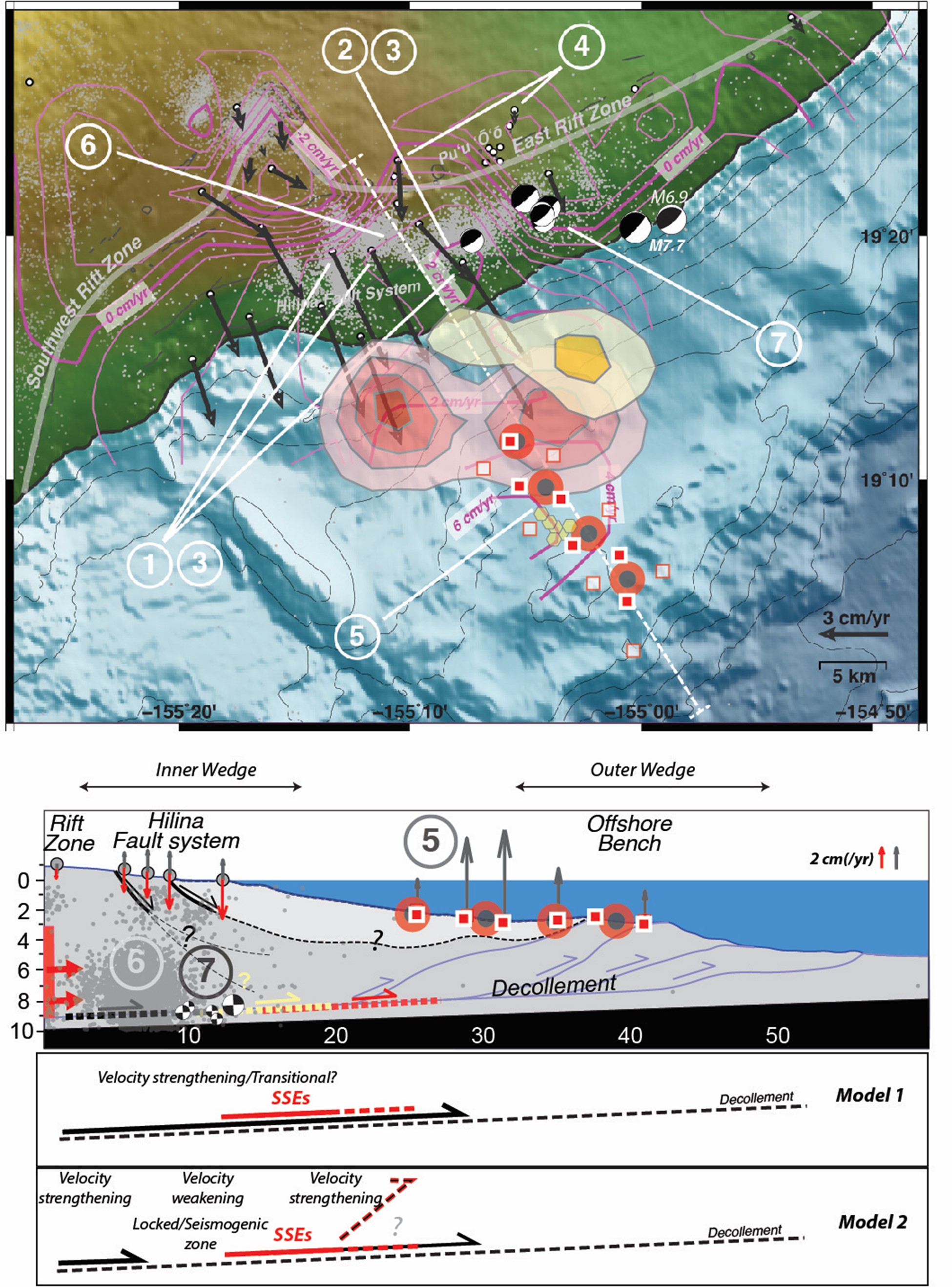
Caption: Kīlauea’s south flank and deployment plan. Top: GPS horizontal rates (black arrows); vertical rate contours (purple); interpreted slow slip event slip regions (red and yellow filled contour regions); campaign pressure benchmarks (red squares); locations of GPS-Acoustic sensors from 2000-2004 (white squares). Seismicity is shown as gray dots, events > M5.5 as beachballs. Locations of our new GNSS-A sites in red circles with black centers. Transparent boxes indicate approximate fault plane solutions for aseismic creep (gray) and the 2018 M7.2 EQ (white). Key observations at Kīlauea: 1) Oceanward horizontal geodetic velocities for flank GNSS sites; 2) Uplift of the subaerial flank; 3) Horizontal to vertical velocity ratio is ~3-4; 4) Horizontal velocities rapidly drop to zero landward of the rift zones; 5) Seafloor geodesy observed ~9 cm/yr uplift between 2000 and 2004; 6) Persistent band of microseismicity seaward of the rift zones; 7) M5+epicenters east of slow slip events and largest secular velocities Bottom: Cross section with vertical rates from GNSS and campaign pressure measurements (gray arrows) and mean SSE vertical motions (red arrows). Model 1 represents the conditions implicit in most published models of geodetically observed aseismic fault creep (black line) and is consistent with the seafloor pressure campaign data. Model 2 is an alternate conceptual model that conforms better with the earthquake data and our evolving understanding of detachment fault behavior. / James Foster
In addition we will perform a campaign survey of ambient seawater pressure measurements, reoccupying benchmarks previously measured in 2004 to recover the 20-year cumulative vertical uplift in the same region and time window that encompassed regular slow-slip events, a major MW 7.2 earthquake, persistent aseismic creep on the décollement, and a change in pressure within Kīlauea’s magmatic system following the dramatic eruption and summit collapse in 2018. A repeat pressure survey during the recovery cruise will provide the uplift rates over this project’s duration, during which we anticipate only aseismic creep as the active fault process. This project will capture a temporal view of the 3-dimensional submarine deformation field and will address the following science and hazard-assessment goals:
- 1) What is the geometry of the fault system offshore?
- 2) Where does slip connected with earthquakes, interseismic creep, and slow-slip events (SSE) occur?
- 3) What processes control stress transfer within the offshore fault system?
- 4) How do these tectonic processes respond to, or impact volcanic events?

James Foster
Prof. Dr.Chair of Geodetic Space Techniques, Dean of Geodesy & Geoinformatics