STREAM (SaTellite Based Runoff Evaluation And Mapping) is a research project funded by European Space Agency (ESA). It is aimed at estimating water discharged in river basins from satellite data. It is to be executed by Institute for Geo-hydrological Protection- National Research Council (IRPI-CNR) and Institute of Geodesy (GIS). IRPI-CNR is the principal investigator in this consortium. The project main objective is estimate fresh water stored on and below landmasses. This is vital for economic and social developments. In situ observations of river discharge typically offer little information on its spatial distribution within a watershed. Furthermore, river discharge observation networks suffer from many limitations such as low station density and a large decline in monitoring capacity in recent years. In addition, hydrological models are highly input demanding based upon complex modelling systems. In view of these limitations, developing innovative methods able to maximize the recovery of information on runoff contained in current satellite observations of climatic and environmental variables becomes mandatory. STREAM will develop a data-driven approach, alternative to existing model-based runoff estimates, for deriving runoff estimates from satellite soil moisture (SM), precipitation (P) and terrestrial water storage anomalies (TWSA).
Total runoff is made up of a slow component, i.e., the return flow from groundwater, and of a fast component, i.e., the sum of the overland flow and of the sub-surface runoff (i.e., subsurface flow through pipes, macropores, and seepage zones in the soil). The precipitation and soil moisture variables will provide the event flow component of the total runoff while terrestrial water storage anomalies will be used for obtaining the total runoff. GIS is primarily responsible for retrieving the base-flow component from data collected by the Gravity Recovery And Climate Experiment (GRACE). GRACE can provide a monthly estimate of total runoff at a limited spatial resolution. The mission provides us with total water storage mass anomalies globally. A method has already been developed in house to convert these storage estimates into corresponding runoff ones.
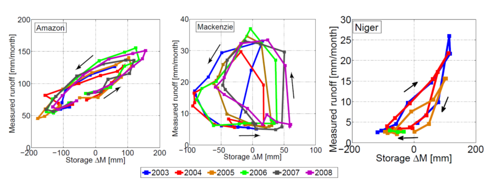
- Riegger J, Tourian MJ (2014) Characterization of runoff-storage relationships by satellite gravimetry and remote sensing, Water Resour Res, 50: 3444 – 3466, doi: 10.1002/ 2013WR013847.
- Tourian MJ, Reager JT, Sneeuw N (2018) The total drainable water storage of the Amazon river basin: A first estimate using GRACE, Water Resour Res, 54: 3290 – 3312, doi: 10.1029/2017WR021674.
Most notably, it is already identified in these publications a linear relationship between runoff and storage. Such a relationship is clearly visible in the supplied picture in which storage (x-axis) versus runoff (y-axis) is displayed at three different catchments in a sequence of years. In STREAM, we study, among others, this linear relationship further and fine tune algorithms to estimate unknown parameters involved in such a transformation.