The lack of comprehensive measurements of freshwater resources is limiting our understanding of the hydrological water cycle. As the data provision from in situ gauge networks is deteriorating, spaceborne geodetic sensors come to the rescue. Among different techniques for estimating river discharge from space, parametric rating curves between the ground-based discharge and spaceborne river water level or width are the most straightforward ones. However, this technique does not always lead to success, since the river section morphology often cannot simply be modeled by a limited number of parameters.
 Water Resources Research, 57 (2021) / Omid Elmi / Figures from Water Resources Research, 57 / (CC BY-NC-ND 4.0)
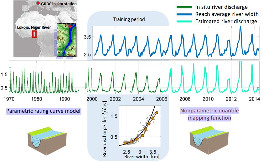
We propose a nonparametric model for estimating river discharge and its uncertainty from spaceborne river width measurements. The algorithm performs the following steps iteratively until it converges: (a) generating realizations of river discharge and width time series using Monte Carlo simulation, (b) obtaining an ensemble of quantile mapping functions by matching all possible permutations of measurement realizations, and (c) adjusting the measurement uncertainties according to the point cloud scatter. The proposed algorithm can mitigate the effect of measurement noise and also possible mismodeling. Moreover, our proposed algorithm delivers a meaningful uncertainty for the estimated discharge and allows us to calibrate the error bars of in situ discharge measurements.